Content
The following are Spot Reports issued by the City of Jacksonville in 2024. If you have questions about the documents below, please contact us.
Below is the Daily Situation Report for today, May 15, 2024
The following are Spot Reports issued by the City of Jacksonville in 2024. If you have questions about the documents below, please contact us.
June
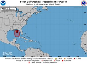 The area of disturbance, AL91, currently has a broad but well-defined circulation and is likely to move over the northeastern Gulf of Mexico through tonight and continue towards the south/southeast on Friday. Disturbance AL91 is expected to bring heavy rainfall over most of the Florida Peninsula through this weekend.
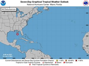 Tropical Depression Two, is currently moving in a south-southeastward motion at a slightly faster forward speed and is expected during the next couple of days. Tropical Depression Two is projected to weaken this evening and should degrade by Saturday.
 Remnants of Tropical Storm Arlene are expected to bring minor to isolated moderate tidal flooding issues along the coast and the St. Johns River. Coastal flooding is anticipated with the high tides at Mayport at 10:00 p.m. and near the Main Street Bridge around 11:15 p.m.
June 1, 2023- 3:25 p.m.
The area of disturbance, AL91, currently has a broad but well-defined circulation and is likely to move over the northeastern Gulf of Mexico through tonight and continue towards the south/southeast on Friday. Disturbance AL91 is expected to bring heavy rainfall over most of the Florida Peninsula through this weekend.
June 2, 2023- 11:18 a.m.
Tropical Depression Two, is currently moving in a south-southeastward motion at a slightly faster forward speed and is expected during the next couple of days. Tropical Depression Two is projected to weaken this evening and should degrade by Saturday.
June 4, 2023- 8:17 p.m.
 Remnants of Tropical Storm Arlene are expected to bring minor to isolated moderate tidal flooding issues along the coast and the St. Johns River. Coastal flooding is anticipated with the high tides at Mayport at 10:00 p.m. and near the Main Street Bridge around 11:15 p.m.